Category 5 hurricane makes landfall on coast of Mexico

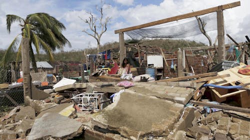
A hurricane made landfall on the coast of Mexico just more than a week ago, and was the strongest recorded hurricane in the history of the Eastern Pacific Ocean, according to the National Hurricane Center.
The hurricane, named Patricia, was upgraded from a tropical storm to a hurricane rapidly as a result of ideal storm growth conditions, said Benjamin Lintner, an associate professor in the Department of Environmental Science.
“It didn’t encounter the large amount of wind shear that would cause the strengthening process to slow down,” Lintner said. “It was really an ideal set of conditions that kind of allowed it to reach the intensity it did.”
In order to form, tropical storms require proper sea temperatures, wind structures, atmospheric moisture and sea currents, Lintner said. Tropical storms can become hurricanes once they cross a wind speed threshold.
The ocean must be sufficiently warm both at the surface and down through a deep layer of the upper ocean. A wind shear, or strong wind, cannot be present for a hurricane to form as it would disturb the structure of the forming cyclone, he said.
Moisture in the atmosphere allows for further growth, and encountering dry air in the atmosphere stops hurricane enlargement. There also needs to be a disturbance that helps give rise to later tropical storm growth, Lintner said.
“In the Atlantic, we often see wave-like structures propagating off of Africa, thunderstorms and things, and those are conditions that can then develop into a tropical depression and then a tropical storm,” he said.
Warm waters and moist atmospheric conditions tend to be found around the equator, but tropical storms do not form right on it. This is because they need a rotational force to start moving, which they can get if they are far enough from the equator, Lintner said.
Hurricanes are observed along the East Coast of the United States because of a high pressure system over the Atlantic that pushes tropical storms north from the Caribbean toward the coast, he said.
Hurricane Patricia quickly grew from a tropical storm to a hurricane due to the ideal conditions in the Eastern Pacific Ocean, Lintner said. There were warm waters, high air moisture and extremely low winds.
“Where Patricia formed was basically a region where we were seeing, at the time ... relative to North America the warmest sea surface temperatures off the southwest coast of Mexico,” he said.
There are competing theories on whether more hurricanes of this intensity will be more common, as increased global climates would increase sea temperatures. Warmer climates would also lead to more water vapor in the atmosphere, Lintner said.
More vapor in the atmosphere would mean more water that can come down as rain. Finally, rising sea levels would worsen storm surges, which are the sea waters that get pushed onshore with the hurricane, Lintner said.
“The presence of increasing sea level ... can exaggerate or exacerbate storm surge,” he said. “I think the jury is still out in terms of what’s going to happen with intense storms.”


